Tuesday, 14 June 2011

Tuesday June 14th

This morning the weather permits us to continue our journey down the Ottawa River to the east.  At Montreal, the Ottawa River joins the St. Lawrence River.  We follow the St. Lawrence River as it continues through low, flat farmland past Trois-Rivieres and then on to Quebec City.  In Quebec City we get a bird’s eye view of the heart of the city passing the Plains of Abraham, the Chateau Frontenac and the confluence of the St. Charles River with the St. Lawrence.  At this point the St. Lawrence flows on either side of the Iles d’Orleans.  We get a great view of the Montmorency Falls and the Basilica of Sainte-Anne-de-Beaupre on the north side of the river.   The river begins to widen after the Iles d’Orleans and tidal influence becomes apparent.   The Gaspe Peninsula on the south side parallels our journey up the North Shore.  Highway 138 winds along the shoreline along our route.

Farmland south of Ottawa River east of Ottawa
Moving Map on Flat Panal Display in our Diamond Aircraft just east of Montreal
Montreal
St. Lawrence River east of Montreal
St. Lawrence River
Approaching Quebec City
Chateau Frontenac, Quebec City
Montmorency Falls just east of Quebec City

We begin our long journey down the North Shore of the Gulf of St. Lawrence.  The Laurentian Mountains come right down to the shoreline.  The mountains are clothed in mixed forest.  Occasionally one sees shear cliffs of bedrock on the sides of domed mountains.  As we proceed north the mountains diminish in height and farming becomes more prevalent.  Charlevoix is very pastoral and looks inviting.  Tourism and cottages are prominent along this part of the North Shore.  The Saguenay River brings a large volume of water into the St. Lawrence at Tadoussac.  The land becomes relatively flat the by the time we reach Baie-Comeau.  We stop here for fuel.  The economy of the towns along this part of the North Shore is tourism, mining and forestry.

Charlevoix
North Shore St. Lawrence
Valbaie River
Looking north at ferries crossing the Saguenay River
Aircraft flat panel showing Saguenay flowing into St. Lawrence; Gaspe Peninsula on the right
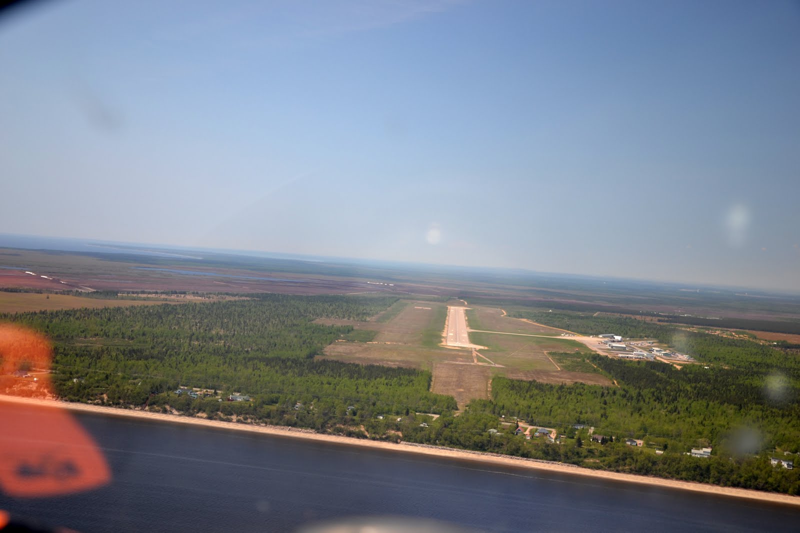
Short final Baie-Comeau
   
The next town of size is Sept-Iles which has a large aluminum smelting facility and shipping terminal.  We continue on up the coast over Havre-Saint-Pierre and the Mignan Archipeligo and Bird Sanctuary. At Natashquan the Highway #138 along the North Shore ends.  This is where the Lower North Shore begins.  The communities between here and just south of Blanc-Sablon rely on boat or air transportation.  We fly over many small communities, some of them out on islands.  There are roads in most of the communities but they are only for local traffic.  The landscape is now shield, lakes and rivers.  The rivers have many waterfalls and rapids which are very visible from the plane.  Remnants of snow drifts become more and more plentiful.   
We arrive in Blanc-Sablon late in the afternoon.  We stop here for fuel.  We are lucky that there is still someone there to fuel our plane as the fellow was actually just leaving to go to his cabin.  The fuel at Blanc-Sablon was very pricy: $2.87 per litre.   After refuelling we head a little further along the coast into Labrador then fly across the Strait of Belle Isle (12 miles) to Newfoundland.  This is the shortest distance across water between the mainland and the “Rock”.   We fly across to the St. Anthony airport which is literally in the middle of no where; 53 km to the town of St. Anthony.  There are so few places to build a runway in this landscape.  After some searching we finally find a taxi to come and pick us up and take us into town. On the way, we count 27 moose!  As we get close to St. Anthony, we see a sizeable ice berg in the one of the bays.    We stay overnight at the Grenfell Heritage Hotel.  Dr. Grenfell was a prominent physician in Labrador and the Northern Peninsula of Newfoundland. 

Monday, 13 June 2011

Monday June 13th


Rain this morning forces us to spend the day in Ottawa.  It is a great place to be if you are stuck on the ground and can’t fly.  There are many choices but we decide to spend the day in the National Gallery of Canada.  It is a beautiful building with amazing views and wonderful exhibits.  The Group of Seven art, as always, is stunning.  

Parliament Buildings & Canadian Museum of Civilization
Canadian Museum of Civilization
Storm Clouds over Ottawa
National Gallery of Canada
Colonnade, National Gallery of Canada
Great Hall, National Gallery of Canada
Spider at entrance to National Gallery of Canada
 

Monday June 13th


Rain this morning forces us to spend the day in Ottawa.  It is a great place to be if you are stuck on the ground and can’t fly.  There are many choices but we decide to spend the day in the National Gallery of Canada.  It is a beautiful building with amazing views and wonderful exhibits.  The Group of Seven art, as always, is stunning.    

Parliament Buildings & Canadian Museum of Civilization
Canadian Museum of Civilization

Sunday, 12 June 2011

Sunday June 12th


We depart Sudbury late Sunday morning.  There is low cloud and rain from Sudbury east towards North Bay.  We follow the north shore of Lake Nippissing where the visibility is best. The rain tapers off at North Bay but the clouds remain low.  Just west of North Bay we pick up the Ottawa River.  At this point the river flows in a narrow channel between its heavily forested banks.  The border between Ontario and Quebec runs down the center of the river.   We follow the river downstream to where it turns south-eastward just north of Petawawa.  As we continue to follow the river downstream, islands begin to appear in the river and farmlands line the side of the river as the whole valley widens out into a plain.  The weather slowly improves and sunshine and scattered clouds replace the grey sky.  We follow the river right into the city, right past the Parliament Buildings, Rideau Canal and Chateau Laurier.  As we fly past one has to think it amazing that, in this day and age, one can actually fly past this site in a small plane.  We land at the Rockcliffe Aerodrome just on the edge of the river east of downtown.  There are towering clouds to the east forewarning a delay in our easterly progression.  We decide to end our travels there for the day and take a taxi into Gatineau to the Sheraton which is directly across the street from the Museum of Civilization.  John and Lynn Steele arrive in C-GMKV and join us at the hotel.
Ottawa River east of North Bay
Ottawa River East of North Bay
Flying down the Ottawa River on the south or Ontario side
Quebec farmland along the Ottawa River

Ottawa River
Flying east along Ottawa River through Ottawa City
Chateau Laurier, Rideau Canal & Parliament Buildings
Turning Final Rockcliffe Aerodrome, Ottawa

Saturday, 11 June 2011

Saturday June 11th

Ron and Chester fly on ahead to Quebec City.  We stay on to visit for another day.  Tony arrives into Sudbury in the early afternoon and we spend a nice day together with the family and celebrate Tony and Anne’s 53rd birthday.  Rain has arrived.
Tony & Anne

Laura, Tony, Erin, Harry, Justin & Anne

Friday, 10 June 2011

Friday June 10th

From Brandon we fly east towards Portage La Prairie and Winnipeg.  Lake Manitoba and Lake Winnipeg are flooding out of their basins and spilling to the south.  We continue to fly into the unusual headwind that has been with us since Calgary.  We fly over a gradual continuum of prairie blending into forest and then into shield and a multitude of lakes.  Cottages begin to appear on the lake shores and become plentiful in the Lake of the Woods.  At Kenora, the lake is dotted with dark isles in shimmering silver water.  Looks so inviting!  We fly over Dryden and search for Eagle Lake where Ron Coutts has a family cabin.  
Lake of the Woods
Kenora


Our next stop for fuel is Thunder Bay on the north-western shore of Lake Superior. The city is bordered on the south by a large headland. Shipping terminals are along the harbour in the bay. A long line of islands offshore provides protection for the bay.  One of these islands, The Sleeping Giant, is very visible from the air. 
Thunder Bay and The Sleeping Giant
Short Final Thunder Bay
Islands Protecting Thunder Bay

A quick stop and then onwards along the north shore of Lake Superior.  We fly at 5500 feet with a cloud layer 2000 feet or so above us.  We traverse over Nipigon and Marathon, and then cut the corner overland to Wawa. 
Nipigon Bay, Nipigon Strait and Black Bay
North Shore Lake Superior

North Shore Lake Superior
Ron & Chester over North Shore Lake Superior

North Shore Lake Superior


From here we turn southeast overflying Chapleau on the way down to Sudbury. When you see Sudbury from the air, you realize that it is a very spread out city in a low basin. Smelter stacks appear in the skyline. The landscape is vegetated now in comparison to the wasteland that was created in the early years of mining. We arrive in late afternoon. Anne’s sister-in-law Laura and the kids Justin and Erin pick us up at the airport. Anne’s twin brother Tony was supposed to arrive back from work in the north tonight but is stuck in Thunder Bay overnight.

Thursday, 9 June 2011

Thursday June 9th

The skies are sunny in Calgary today, so we decide to leave a day earlier than planned.  We depart from Springbank at 2:00 pm accompanied by Ron Coutts and Chester Allan in C-FYAY.  Heading east, we fly over the flooded farmlands of southern Alberta.  There is an irony in the wet fields that the farmers are struggling to plant crops because of flooding in southern Alberta and the forest fires that are raging out of control in the dry conditions in northern Alberta. 

Flooding worsens as we fly through Saskatchewan and Manitoba. The South Saskatchewan River is muddy and bank full. We land in Regina for fuel; newly formed lakes everywhere on the landscape as there is no where in this flat prairie for the water to go.   On towards Brandon, houses and farm buildings looking like islands in a shallow sea. The Assiniboine River has also swollen to bank full; the only evidence of the normal meandering channel is the tops of poplars, looking like they are treading water.  In isolated places, there are tractors trying to seed small areas of higher ground.  Brandon is already a month past high water but the Assiniboine River is still very high, covering all the parks and campgrounds on the floodplain.  A flying friend of a friend kindly picks us up at the airport and drives us into town to the hotel and returns us to the airport the next morning.